St. Lawrence Valley Anti-Submarine
Radar System in World War II
In March 1943, at RCAF request, the Canadian Army provided ten GL Mark III (anti-aircraft artillery control) radar sets for deployment at ten mile intervals from Matane to Gaspé and created No 1 Radar Direction Finding Operating Unit, Royal Canadian Artillery to man them. These sets could detect submarines at a range of 25 kilometers. The first two were operational in June 1943 and six by July 1943.
In May 1943 experimental Microwave Early Warning (MEW) sets were rushed into production. Eight sets were ordered by the RCAF to cover Cabot Strait, Strait of Belle Isle and the Gaspé Passage. The first experimental station was erected near Fox River (Gaspé) (75 RU) in 1943. This experimental MEW set was first put into operation in July 1943. It had been built to operate for a period of months at the most. At time of shut down, September 18, 1944, it was still operating in a satisfactory manner.
It has been determined that MEW/AS radar equipment was installed at 75 RU Fox River, QC and became operational on 12 September 1944. This unit was closed down on 30 November 1944 due to the close of the shipping season when the channel was iced up.
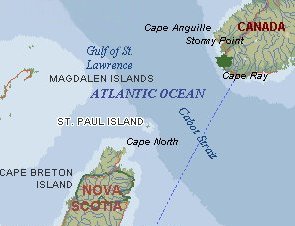
It has been determined that MEW/AS radar equipment was installed at 76 RU St. Paul Island, NS in October 1944. This radar was operational in early November 1944 and it was closed down on 1 December 1944 - having been operational for a period of just one month.
It has also been determined that MEW/AS radar equipment was installed at 77 RU Cape Ray, NF and became operational during the summer of 1944. Only one probable submarine contact was made and reported to the Filter Room during the summer
of operation, but the turning-away of a ship from the contact area perhaps made the whole exercise worthwhile.

St. Paul Island lies about 44 miles from Cape Ray, Newfoundland.
There would have been some overlap in radar coverage between these two locations.
It appears that the MEW/AS radar at Fox River, St. Paul Island and at Cape Ray was moth-balled before the winter of 1944-1945 made supply difficult, as well as reduced submarine activity when the channel was iced up. By the spring of 1945, it had become apparent that the European part of the war was winding down, so the stations were never re-opened. It has also been argued that by the time the operational sets were installed in 1944, submarine tactics had rendered them useless and the chain was never completed.
|
This page is located at
http://www.pinetreeline.org/rds/detail/rds76-6.html
Updated: May 29, 2004
|
